


Naviator

Perihal Naviator
This is a 30 day free trial of Naviator. Please see the "Subscription Information" section below for more details.
Notice: we do not provide customer support via Play Store reviews. Please contact our Support Team for customer support issues.
Naviator is a full-featured moving map GPS app for pilots. For less than the price of an hour of fuel you can have access to GPS navigation technology that would have cost thousands of dollars only a few years ago!
Quickly and easily share your flights with your friends on Naviator Hangar! (http://hangar.naviatorapp.com/)
FEATURES:
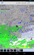
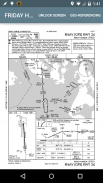
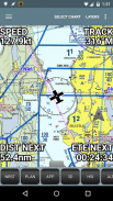
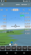
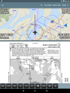
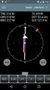
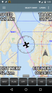
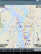
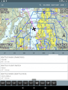
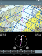
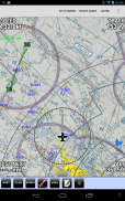
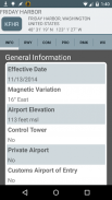
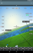
• GPS moving map with airspace, airports, radio navigation aids, airway intersections, TFRs
• All navigational data is downloaded to your device - no internet connection is required while you are flying
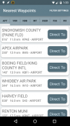
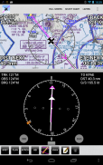
• Easy "rubber band" flight planning
• Support for ADS-B receivers including the iLevil AW/SW, Dual XGPS 170 and XGPS 190, Navworx, SkyGuardTWX, Flight Data Systems Pathfinder, Stratux, FlightBox, uAvionix pingBuddy and various receivers from FreeFlight Systems
• Integrates with ADS-B or the Zaon XRX for real-time traffic display
• NEW! AOPA members can import their stored routes from the AOPA Flight Planner
• NEW! Import custom airspace from OpenAir airspace files
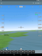
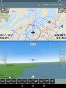
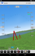
• 3D synthetic vision with terrain, obstacles/towers and runways
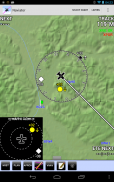
• Global terrain database with terrain warnings
• Global Forecast Engine provides winds aloft anywhere on the planet up to 54,000 feet
• GPS track recording - upload your flight recordings to your own personalized Naviator Hangar (http://hangar.naviatorapp.com)
• Import routes from other flight planning systems using the GPX format
• Integrates with Microsoft Flight Simulator and Prepar3D
• Integrates with X-Plane using the "X-Plane to GPS" app (https://play.google.com/store/apps/details?id=com.appropel.xplanegps)
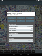
• Get a weather briefing and file a flight plan from right inside the app
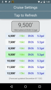
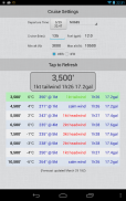
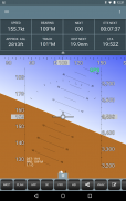
• Vertical navigation (VNAV) calculator
• Canadian data including airspace, airports, navaids, terrain and weather
• NMEA output - Naviator can drive your aircraft's autopilot
• "Bring Your Own Charts" - you can import custom maps and charts into the app. See our forum for more details.
Our support forum is located at http://forum.naviatorapp.com/
SUBSCRIPTION INFORMATION:
Subscriptions provide access to all app, chart and data updates for the duration of the subscription.
PRICING:
Naviator is free of charge for the first 30 days of use. After this free trial period, the following items may be purchased:
(a) 30 Day Chart Subscription - $4.99 USD
Enables full app access for 30 days*
(b) 1 Year Chart Subscription - $34.99 USD
Enables full app access for one year*
(c) Unlock Naviator - $14.99 USD
Intended for pilots who do not fly in the United States, this one-time charge permanently unlocks all features of Naviator, except FAA approach plates, sectionals, TACs, IFR enroute charts, TFR updates and the "BYOC" feature.
Includes database updates, weather updates, high-detail VFR base map, terrain database and 3D synthetic vision
* geo-referenced approach plates require an optional subscription from Seattle Avionics. See our website for details.
Ini adalah percubaan 30 hari percuma Naviator. Sila lihat bahagian "Maklumat Langganan" di bawah untuk maklumat lanjut.
Notis: kami tidak menyediakan sokongan pelanggan melalui ulasan Play Store. Sila hubungi Pasukan Sokongan kami untuk isu-isu sokongan pelanggan.
Naviator adalah peta bergerak aplikasi yang lengkap GPS untuk juruterbang. Kurang daripada harga sebuah jam bahan api anda boleh mempunyai akses kepada teknologi navigasi GPS yang akan mempunyai beribu-ribu kos dolar hanya beberapa tahun yang lalu!
Dengan cepat dan mudah berkongsi penerbangan anda dengan rakan anda di Naviator Hangar! (Http://hangar.naviatorapp.com/)
CIRI-CIRI:
• GPS peta bergerak dengan ruang udara, lapangan terbang, alat bantuan pelayaran radio, persimpangan saluran udara, TFRs
• Semua data pelayaran dimuat turun ke peranti anda - tiada sambungan internet diperlukan semasa anda terbang
• Mudah "band getah" perancangan penerbangan
• Sokongan untuk penerima ADS-B termasuk iLevil AW / SW , Dual XGPS 170 dan XGPS 190 , Navworx , SkyGuardTWX , Penerbangan Data Systems Pathfinder , Stratux , FlightBox , uAvionix pingBuddy dan pelbagai penerima daripada FreeFlight Systems
• Mengintegrasikan dengan ADS-B atau Zaon XRX untuk paparan trafik masa nyata
• NEW! AOPA ahli boleh mengimport laluan disimpan mereka dari Planner AOPA Penerbangan
• NEW! Import ruang udara adat dari fail ruang udara Openair
• Pandangan sintetik 3D dengan rupa bumi, halangan / menara dan landasan
• pangkalan data kawasan Global dengan amaran rupa bumi
• Ramalan Engine Global menyediakan angin Panji mana-mana sahaja di planet ini sehingga 54,000 kaki
• Rakaman trek GPS - memuat naik rakaman penerbangan ke sendiri peribadi Naviator Hangar anda (http://hangar.naviatorapp.com)
• Laluan Import dari sistem perancangan penerbangan lain yang menggunakan format GPX
• Mengintegrasikan dengan Microsoft Flight Simulator dan Prepar3D
• Mengintegrasikan dengan X-Plane menggunakan "X-Plane untuk GPS" app (https://play.google.com/store/apps/details?id=com.appropel.xplanegps)
• Dapatkan taklimat cuaca dan memfailkan rancangan penerbangan dari kanan di dalam app
• navigasi menegak (VNAV) kalkulator
• Data Kanada termasuk ruang udara, lapangan terbang, navaids, rupa bumi dan cuaca
• Output NMEA - Naviator boleh memandu autopilot pesawat anda
• "Bawa Carta Anda Sendiri" - anda boleh mengimport peta adat dan carta ke dalam app. Lihat forum kami untuk maklumat lanjut.
forum sokongan kami terletak di http://forum.naviatorapp.com/
MAKLUMAT LANGGANAN:
Langganan menyediakan akses kepada semua aplikasi, carta dan data kemas kini sepanjang tempoh langganan.
HARGA:
Naviator adalah percuma untuk 30 hari pertama penggunaan. Selepas tempoh ini percubaan percuma, perkara-perkara berikut boleh dibeli:
(A) 30 Hari Carta Langganan - $ 4.99 USD
Membolehkan akses app penuh selama 30 hari *
(B) Carta 1 Tahun Langganan - $ 34.99 USD
Membolehkan akses app penuh selama setahun *
(C) Unlock Naviator - $ 14.99 USD
Khas untuk juruterbang yang tidak terbang di Amerika Syarikat, caj satu kali ini tetap membuka semua ciri Naviator, kecuali pendekatan FAA pinggan, sectionals, Tacs, IFR carta dalam perjalanan, kemas kini TFR dan ciri "BYOC".
Termasuk kemas kini pangkalan data, maklumat terkini cuaca,-detail yang tinggi asas VFR peta, pangkalan data rupa bumi dan visi sintetik 3D
* Rujukan geo-pendekatan plat memerlukan langganan pilihan dari Seattle Avionics. Lihat laman web kami untuk maklumat lanjut.
Naviator - Versi 4.2.2
(21-12-2020)
Naviator - Maklumat APK
Versi APK: 4.2.2Pakej: com.onetwentythree.skynavVersi Terkini Naviator
Versi lain


Aplikasi dalam kategori sama

Anda juga mungkin suka...


